


Расширенный высокоцелевый V90 gps rtk дифференциальный rover HI TARGET
- Категория: Other Test Instruments >>>
- Поставщик: Suzhou,Super,Gis,Technology,Co.,Ltd.
Поделиться:
Описание и отзывы
Трекер стоимости
| Месяц | Минимальная цена | Макс. стоимость |
|---|---|---|
| Sep-17-2025 | 7140.79 $* | 7497.28 $* |
| Aug-17-2025 | 7080.48 $* | 7434.15 $* |
| Jul-17-2025 | 5940.71 $* | 6237.25 $* |
| Jun-17-2025 | 6960.51 $* | 7308.74 $* |
| May-17-2025 | 6060.0 $* | 6363.47 $* |
| Apr-17-2025 | 6840.21 $* | 7182.58 $* |
| Mar-17-2025 | 6780.93 $* | 7119.23 $* |
| Feb-17-2025 | 6720.93 $* | 7056.94 $* |
| Jan-17-2025 | 6660.86 $* | 6993.57 $* |
Характеристики
Product Description
KEY FEATURES
Multi-constellation Tracking
• 220 trackir19 channels.
• NGS approved full-wave GNSS antenna.
•Supparts GPS, GLONASS, GALILEO, BOS, SBAS.
•Supparts a wide range of satellite signals.
•Alarge receiving area designed for multipath mitigation.
•Airdi electric is light and stable.
Smart Application
* Supports electronic bubble calibration.
* Offers tilt survey with a maximum tilt angle of 30 degrees.
* The internal NFC module makes Bluetooth communication quick and easy.
* Intelligent voice assistance guides field operations. Voice can be DIY.
* Standard Rinex data and HI-TARGET raw data recorded simultaneously.
Optional Transceiver UHF Radio
* The transceiver UHF radio enables switchable working modes between base and rover.
* Three types of internal UHF radio provide different frequencies based on users requirements.
* The Pacific Crest TrimTalk internal UHF radio is compatible with other radios.
Multi-network Connection
* Supports GPRS, GSM and WCDMA.
* Supports WIFI.
Powerful Battery
* Powered by high-capacity (5000mAh) Li-ion battery to ensure full day operation.
Rugged Design
* IP67 dustproof and waterproof.
* Able to survive a 3-meter natural fall onto concrete.
iHand30 Field Controller
Default Configuration
Post-processing Software
HI-TARGET Geomatics Office (HGO) software
* Provides the complete GPS/GLONASS/BDS/GALILEO processing solution.
* Standard Rinex data format and Hi-Target raw data format can be processed flexibly and easily.
* Easy operat1on
Specification
V90 PERFORMANCE SPECIFICATIONS | |
Statellite Signals Tracked Simultaneously | |
Channel | 220 Channels |
GPS | Simultaneous L1C/A, L2C, L2E, L5 |
GLONASS | Simultaneous L1C/A, L1P, L2C/A, (GLONASS M only), L2P |
SBAS | Simultaneous L1C/A, L5 |
Galileo | Simultaneous L1 BOC, E5A, E5B, E5AltBOC1 |
BDS | B1, B2 |
QZSS | L1C/A, L1 SAIF, L2C, L5 |
POSITIONING PERFORMANCE2 | |
Static and Fast Static GNSS Surveying | |
Horizontal | 2.5mm+0.5ppm RMS |
Vertical | 5mm+0.5ppm RMS |
Post Processing Kinematic (PPK / Stop & Go ) GNSS Surveying | |
Horizontal | 1mm+1ppm RMS |
Vertical | 2.5mm+1ppm RMS |
Initialization time | Typically 10 minutes for base while 5 minutes for rover |
Initialization reliability | typically > 99.9% |
Real time Kinematic (RTK) surveying | |
Single Baseline | |
Horizontal | 8mm+1ppm RMS |
Vertical | 15mm+1ppm RMS |
Network RTK | |
Horizontal | 8mm+1ppm RMS |
Vertical | 15mm+1ppm RMS |
Initialization time | typically < 8 seconds |
Initialization reliability | typically > 99.9% |
Code Differential GNSS Positionnig | |
Horizontal | 25cm+1ppm RMS |
Vertical | 50cm+1ppm RMS |
SBAS | 0.50m Horizontal, 0.85m Vertical |
COMMUNICATION | |
Network Communication | |
Fully integrated, fully sealed internal WCDMA, compatible with GPRS, GSM | |
Wifi frequency is 2.4G, supports 802.11b/g/n protocol802.11b/g/n | |
Network RTK (via CORS) range20-50km | |
HI-TARGET Internal UHF Radio(Standard) | |
Frequency | 450~470MHz with 116 channels |
Transmitting power | 1W,2W, 5W adjustable |
Transmitting speed | 9.6Kbps, 19.2Kbps |
Working range | 5km typical, 8~10kmoptimal |
HI-TARGET External UHF Radio(Standard) | |
Frequency | 460MHZ with 116 channels |
Transmitting power | 5W,10W,20W,30W adjustable |
Transmitting speed | Up to 19.2Kbps |
Working range | 8~10km typical,15~20km optimal |
HARDWARE | |
Physical | |
Dimensions(W×H) | 153mm×83mm(6.02inch×3.27inch) |
Weight | 950g(2.09(b)without internal battery |
Operating temperature | —40℃ to+65℃(—40℉ to+149℉) |
Storage temperature | —55℃ to+85℃(—67℉ to+185℉) |
Humidity | 100%,considering |
Water/dustproof | IP67 dustproof,protected from temporary |
immersion to depth of 1m(3.28ft) | |
Shock and vibration | Designed to survive a 3m(9.84ft) |
natural fall onto concrete | |
Electrical | |
Power 6V to 28V DC external power input | |
Power consumption≤3.5W | |
Automatic switching between internal power and external power | |
Rechargeable,removable 7.4V, | |
5000mAh Lithium-ion battery in internal battery compartment | |
Internal Battery Life | |
Static more than 10 hours | |
RTK rover (UHF/GPRS/3G)6—10 hours | |
RTK base more than 6 hours | |
I/O Interface | |
Bluetooth, NFC | ×1 |
standard USB2.0port | ×1 |
TNC antenna connector | ×1 |
RS232 serial port | ×1 |
DC power input (5—pin) | ×1 |
MicroSD card port | ×1 |
Tilt Survey System | |
Electronic Bubble | |
SYSTEM CONFIGURATION | |
SYSTEM | |
Data storage | 16GB internal storage+Internal Micro SD |
Card memory (Support up to 32GB extension) | |
Record GNS and Rinex format simultaneously |
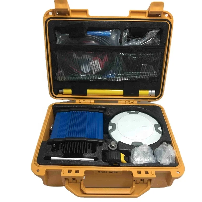
Packing & Delivery

Company Profile


At SUPERGIS we pride ourselves on the quality and range of products and services we offer to our customers. We supply everything from the simplest of survey accessory such as nails or spray paintthrough to the full range of surveying equipment, total stations and RTK.
With years of experience in providing a quality service to the civil engineering, surveying and construction industries we are committed to innovating the service we can provide to our customers by adding new innovative products,solutions and services to our customers.
With years of experience in providing a quality service to the civil engineering, surveying and construction industries we are committed to innovating the service we can provide to our customers by adding new innovative products,solutions and services to our customers.
Our service
Customer Care
At our Customer Service department, we receive your enquiries, compliments and complaints and channel them to those deserving. We also follow up on your complaints and queries to ensure that you get immediate answers to all your enquiries.
For queries that require investigation and consultation, we ensure to get the expert and let you know the status within reasonable time.
FAQ
HOW IS THE EXPORT SERVICES ?
We offer a comprehensive and efficient export service including:
* Packaging and transportation worldwide
* Insurance where required
* Customs documentation
WILL THE PRICE OF YOUR PRODUCTS EVER CHANGE?
All prices are shown in USD (United States Dollar). All goods are sold subject to availability. Both price and availability information is subject to change without notice, hence any subsequent purchases of the same product cannot be guaranteed at the same price. While we take the utmost care to ensure the product descriptions, pictures, information and prices are accurate we do not accept liability for any inaccuracies, errors or omissions. Despite our best efforts, a small number of items displayed on our
site may be mispriced.
WHAT ARE THE SHIPPING CHARGES ?
Shipping and handling charges are based on order weight.
ARE ALL OF YOUR PRODUCTS SHOWN ONLINE?
Not all of our products are shown online,Please contact us and let us know what you are looking for. Chances are we can find it, as long as its surveying related.
WHATS YOUR PAYMET METHOD ?
We accept wire transfer ,paypal,moneygram,western union and Alibaba Trade Assurance online payment (credit card )
HOW CAN YOU MAKE SURE MY PAYMENT IS SAFE?
We can make deal on Alibaba Trade Assurance if the trust problem exist as Alibaba as the third party will guarantee your payment until you receive your order and confirm everything is all right .
WHAT ABOUT THE WARRANTY OF YOUR INSTRUMENT ?
We offer one year warranty of GNSS,TOTAL STATION,THEODOLITE AND AUTO LEVEL.
YOU MAY LIKE


Contact us
JESSICA JIANG
SKYPE:JESSICA JIANG71
TEL:0512-50128487
MOBILE:+86-18772319050
ADD:RM365,BLD3,NO258,LVDI RD,SUZHOU,CHINA
SKYPE:JESSICA JIANG71
TEL:0512-50128487
MOBILE:+86-18772319050
ADD:RM365,BLD3,NO258,LVDI RD,SUZHOU,CHINA


