
Недорогой приемник gnss V98 rtk gps с внутренним хранилищем на 16 ГБ и функциями
- Категория: Other Test Instruments >>>
- Поставщик: Shanghai,Hexin,Survey,Instrument,Company,Ltd.
Поделиться:
Описание и отзывы
Трекер стоимости
| Месяц | Минимальная цена | Макс. стоимость |
|---|---|---|
| Sep-18-2025 | 6902.15 $* | 7247.45 $* |
| Aug-18-2025 | 6844.83 $* | 7186.93 $* |
| Jul-18-2025 | 5742.13 $* | 6029.72 $* |
| Jun-18-2025 | 6728.44 $* | 7064.55 $* |
| May-18-2025 | 5858.14 $* | 6151.40 $* |
| Apr-18-2025 | 6612.87 $* | 6943.83 $* |
| Mar-18-2025 | 6554.81 $* | 6882.7 $* |
| Feb-18-2025 | 6496.56 $* | 6821.35 $* |
| Jan-18-2025 | 6438.85 $* | 6760.28 $* |
Характеристики
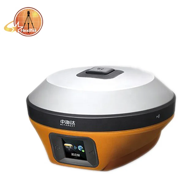
Cheap gnss receiver Hi - target V98 rtk gps with With 16GB internal storage and OTG functions
Hi-target V98 is the new high quality GNSS receiver of Hi-Target, benefiting from the next-generation GNSS engine, supporting the PPP service. It has full band support for cellular mobile networks (LTE, WCDMA, EDGE,GPRS,GSM), and supports most of the radio protocols on an internal UHF transceiver radio.
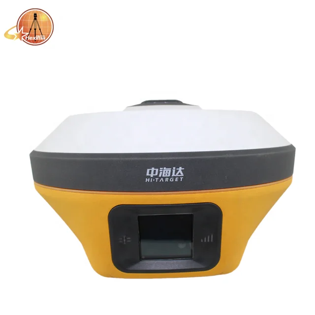
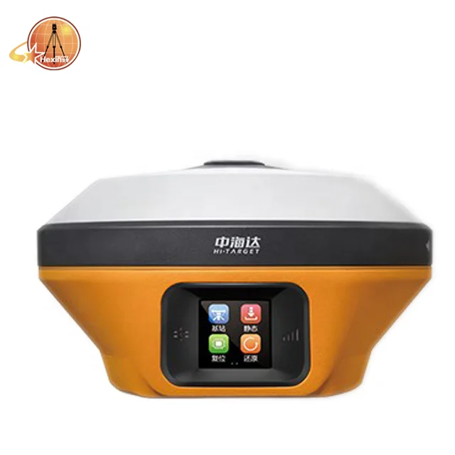
V98 has an innovative designs, a magnesium alloy structure and the Linux 3.2.0 operating system. The HD OLED color touch screen has a better display, and operates in rain. V98 is an industry-leading GNSS RTK surveying solution.

Key features of Hi - target v98
1.) With the next-generation GNSS engine BD990, the new intelligent V98 can provide an intelligent, integrated solution for surveying and mapping. It supports full constellation and multiple channels with Maxwell7 technology, can achieve a four-star tri-band solution and can fix a position quickly and reliably. It supports the PPP service, has the accuracy of stand-alone precision positioning to an accuracy of 4cm globally. The HD OLED color touch screen can do a better display, and it’s operational in rain.
2. )With 16GB internal storage, it supports OTG functions. Full band support for cellular mobile network with a built-in 4G network antenna. With a 360° omni-directional wireless radio antenna and internal UHF radio, it supports multiple radio protocols. It supports WiFi, bluetooth and NFC (near field communication). It supports tilt survey with the internal electronic bubble. With a 6800mAh lithium-ion rechargeable and removable smart battery, it supports a quick charge and power display with the LED. Stronger with innovative designs and magnesium alloy structure.
3. )Double format storage of static data (GNS / RINEX). With the new generation controller iHand30 supports 4G, WiFi, OTG, quick charge and so on. With the new Hi-Survey software with new UI, multiple base maps and so on.
4. )V98 GNSS RTK SYSTEM
Benefiting from the next-generation GNSS engine, unlimited communication technology and innovative designs, IRTK5, the high quality scalable GNSS receiver, provides an industry-leading GNSS RTK surveying solution


5. )HI-RTPIM Global PPP Service
The correction source has been extended by HI-RTPTM global correction service provided by Hi-target. Enabling users to work without a base-station in rural or remote areas anywhere in the world.
-Provide centimeter-level global precision
-Harness all constellation signals from BDS, GLONASS, GPS, GALILEO
-More than 220 reference stations
-L band satellite radio/internet broadcast
6.) Unlimited Communication
360mni-directional Antenna and Multi-protocol Radio
The top-mounted radio antenna extends the radio working range and enables full omni-directional communication, making the transmitting and receiving distance more than 20% longer Multi-protocol radio, support Hi-target, TRIMTALK450S, TRIMMARK III, TRANSEOT, SATEL-3AS, SOUTH. CHC
7. )Revolutionary Tilt Survey with Built-in IMU
 | Customer benefit from calibration free for tilt survey without centering. Once you reach the surveying points, immediately start the operation. Compared with bubble leveling, boost working efficiency by 20% |
8. )Hi – Survey Software
Brand new UI,easier to unstand and use.
Professional programs in road application such as side slop settingout, DTM stakingout etc
Basemap from online maps, DXF and SHP date
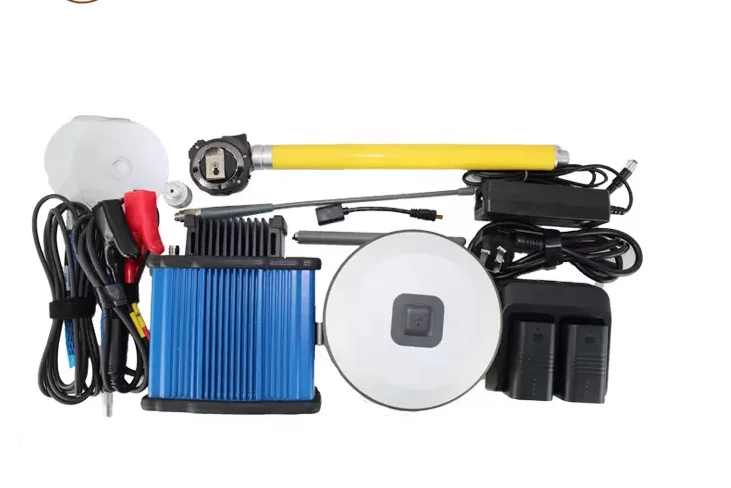
9. )iHand30 Field Controller
Default Configuration

The iHand30 is designed for intelligent RTK with NFC sensor, a durable keyboard, ultra-long battery life and sensitive touchscreen, preinstalled free and intelligent Hi-Survey software. Hi-Survey software is the first high-precision survey software of Hi-Target running on the Android platform, supports tilt survey and electronic bubble, can perfectly cooperate with V98.


Product Description
V98 PERFORMANCE SPECIFICATIONS | |
Channels | 336 Channels |
GPS | Simultaneous L1C/A, L2C, L2E, L5 |
GLONASS | Simultaneous L1C/A, L1P, L2C/A, L3CDMA |
SBAS | Simultaneous L1C/A, L5 |
Galileo | Simultaneous L1 BOC, E5A, E5B, E5AltBOC1 |
BDS | B1, B2 B3 |
SABS | L1C/A, L1, L5 |
POSITIONING PERFORMANCE | |
Static and Fast Static GNSS Surveying | |
Horizontal | 2.5mm+0.5ppm RMS |
Vertical | 5mm+0.5ppm RMS |
Post Processing Kinematic (PPK / Stop & Go ) GNSS Surveying | |
Horizontal | 8mm+1ppm RMS |
Vertical | 15mm+1ppm RMS |
Initialization time | Typically 10 minutes for base while 5 minutes for rover |
Initialization reliability | typically > 99.9% |
Single Baseline | |
Horizontal | 8mm+1ppm RMS |
Vertical | 15mm+1ppm RMS |
Network RTK | |
Horizontal | 8mm+0.5ppm RMS |
Vertical | 15mm+0.5ppm RMS |
Initialization time | typically < 10 seconds |
Initialization reliability | typically > 99.9% |
Tilt survey performance | |
2cm accuracy in the inclination of 30 degree | |
COMMUNICATION | |
Network Communication | |
Fully integrated, fully sealed internal WCDMA, compatible with GPRS, GSM | |
HI-TARGET Internal UHF Radio(Standard) | |
Frequency | 403~473MHz |
Transmitting power | 1-4W adjustable |
Working range | 5km typical, 5~8kmoptimal |
HI-TARGET External UHF Radio(Standard) | |
Frequency | 410-470MHZ |
Transmitting power | 5W,25W, adjustable |
Working range | 8~10km typical,15~20km optimal |
HARDWARE | |
Physical | |
Dimensions(W×H) | 158mm×98mm(6.22inch×3.86inch) |
Weight | 1.3kg (2.65(b)with internal battery |
Operating temperature | —40℃ to+75℃(—40℉ to+167℉) |
Storage temperature | —50℃ to+85℃(—58℉ to+185℉) |
Humidity | 100%, considering |
Water/dustproof | IP67 dustproof, protected from temporary |
Shock and vibration | Designed to survive a 3m(9.84ft) |
Electrical | |
Power 6V to 28V DC external power input | |
Automatic switching between internal power and external power | |
Rechargeable 7.4V, | |
Internal Battery Life | |
Static more than 10 hours | |
RTK rover (UHF/GPRS/3G)10 hours | |
RTK base more than 10 hours | |
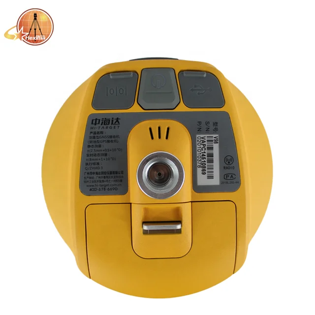
I/O Interface | |
Bluetooth, NFC | ×1 |
standard USB2.0port | ×1 |
TNC antenna connector | ×1 |
RS232 serial port | ×1 |
DC power input (5—pin) | ×1 |
MicroSD card port | ×1 |
Tilt Survey System | |
Data storage | 16GB internal storage+Internal Micro SD |
Record GNS and Rinex format simultaneously | |
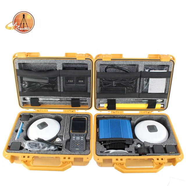
Packaging & Shipping
Packaging is absolutely fine, high-end and upscale. We have been dealing with foreign clients for more than 8 years. Before leaving the factory, every part is strictly tested.Please rest assured that we have all the necessary accessories for the instrument.
We have strong cooperation with DHL, TNT, UPS, FEDEX,EMS,China Air Post.
You can also choose your own shipping forwarder.

Payment
Generally, we accept Trade Assurance, Paypal, Advance T/T, and West union.
If you prefer other payment terms, please let us know.
Company Information
Company Information
With 8 years' experience in geodetic surveying and cadastration surveying, we are a professional and leading enterprise in the surveying industry in Mainland China. We specialize in the R&D and manufacturing and sales of all kinds of surveying products, including total station, electronic theodolite, electronic distance meter, automatic level, laser level, reflector prism, surveying accessory, GPS receiver, mapping software, etc.
The marketing model advocated by us is not a simple sense of "selling products", instead, pre-sales service, services during operation and after-sales service are integrated in entire operating activities. It makes the customers feel that they purchased not only a commodity, but also a professional service.
We welcome new and old customers from all walks of life to contact us for future business relationships and achieving mutual success!

FAQ
Payment:
Generally, we accept Trade Assurance, Paypal, Advance T/T, and West
union.If you prefer other payment terms, please let us know.
Delivery:
1.Usually, we will send out the products within 3-5 working days after the payment confirmed.
2.Before shipment, pls supply the following information to us :
Contact person or company name
Detail address
Telephone No
Zip code
3.The buyer are responsible for the tax and/or duty charged by their country.
Return and warranty:
1.All products are inspected before shipment, if you are not satisfactory with the purchase,you can exchange the items in one week,and you must contact us within 24 hour of receipt of the products.
2.The shipping charges are not refundable and the customer should be responsible for all the charges of return and reshipping.
Feedback:
Customer's feedback will be high appreciated after receive the items. Since your feedback are very important four our business development.
If you have any questions, please feel free to contact me.
Please click on me to let you have more surprise !
Please click on me to let you have more surprise !


