
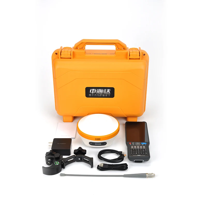
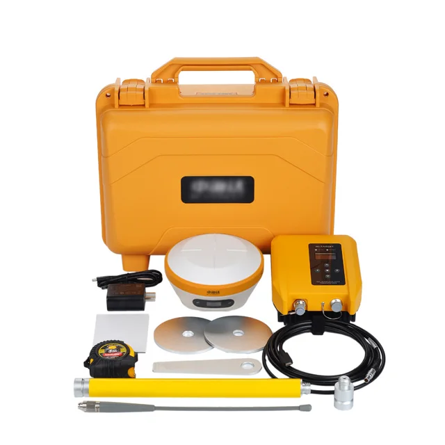
Высокоточный высокоцелевый Gnss Rtk V96 обновленный irtk4 или D8 VR для съемки земли инструмент Gps GNSS base
- Категория: Other Electronic Measuring Instruments >>>
- Поставщик: Sichuan,Cetuzhe,Space,Information,Technology,Co.,Ltd.
Поделиться:
Описание и отзывы
Трекер стоимости
| Месяц | Минимальная цена | Макс. стоимость |
|---|---|---|
| Aug-15-2025 | 5333.30 $* | 5440.46 $* |
| Jul-15-2025 | 4325.4 $* | 4412.35 $* |
| Jun-15-2025 | 5249.2 $* | 5354.5 $* |
| May-15-2025 | 5207.34 $* | 5311.29 $* |
| Apr-15-2025 | 4157.61 $* | 4240.38 $* |
| Mar-15-2025 | 5123.25 $* | 5225.63 $* |
| Feb-15-2025 | 5081.34 $* | 5183.74 $* |
| Jan-15-2025 | 5039.42 $* | 5140.77 $* |
Характеристики
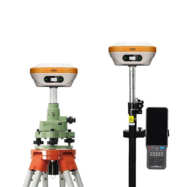
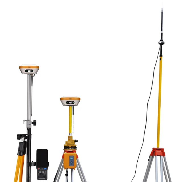
Product Description


Product Paramenters
V2 technical parameters | ||
GNSS configuration | Number of channels: 1408 | |
Satellite Tracking: BDS: B11, B2I, B3I, B1C, B2a, B2b* | ||
GPS: LIC/A, LIC, L2P(Y), L2C, L5 | ||
GLONASS: L1, L2 | ||
GALILIEO: E1, E5a, E5b, E6* | ||
QZSS: L1, L2, L5, L6* | ||
IRNSS: L5* | ||
SBAS: L1, L2, L5 | ||
Output format ASCII: NMEA-0183, binary code | ||
Positioning output frequency: 1Hz~20Hz | ||
Static data format: GNS, Rinex dual format static data | ||
Differential format: RTCM2.X, RTCM3.X | ||
Network mode: VRS, FKP, MAC; support NTRIP protocol | ||
System Configuration | Operating system: Linux operating system | |
Data storage: built-in 8GB ROM, support automatic cycle storage of static data | ||
Accuracy and Reliability | RTK positioning accuracy: plane: ±(8 1x10⁻⁶D) mm (D is the distance between the measured points) | |
Elevation: ±(15 1x10⁻⁶D) mm (D is the distance between the measured points) | ||
Static positioning accuracy: plane: ±(2.5 0.5x10⁻⁶D) mm (D is the distance between the measured points) | ||
Elevation: ±(5 0.5x10⁻⁶D) mm (D is the distance between the measured points) | ||
DGPS positioning accuracy: plane accuracy: ±0.25m 1ppm; elevation accuracy: ±0.50m 1ppm | ||
SBAS positioning accuracy: 0.5m | ||
Tilt measurement accuracy: 8mm 0.7mm/°tilt | ||
Image Stakeout Accuracy: Typical Accuracy: 2cm | ||
Initialization time: | ||
Initialization reliability: >99.99% | ||
Resume from breakpoints: RTK measurements are still available during differential signal interruptions | ||
Camera | Pixels: Professional high-performance HD camera, 2MP | |
Function: support real scene stakeout | ||
communication unit | USB type C interface; SMA interface; Nano SIM card slot | |
eSIM card: Support dual eSIM for console and handbook, dual network and dual standby, including 3 years of traffic, high precision when turned on | ||
Built-in 4G network: TDD-LTE, FDD-LTE, WCDMA, TD-SCDMA, EDGE, GPRS, GSM | ||
WiFi communication: 802.11 a/b/g/n access point and client mode, can provide WiFi hotspot service | ||
Bluetooth communication: Bluetooth 4.2/2.1 EDR, 2.4GHz | ||
Built-in radio: built-in full-protocol transceiver integrated radio | ||
Power: 0.5W/1W/2W adjustable | ||
Frequency band: 410MHz~470MHz | ||
Protocol: HI-TARGET, TRIMTALK450S, TRIMMARKIII, TRANSEOT, SOUTH | ||
Number of channels: 116 (16 of which are configurable) | ||
Plug-in radio: HDL460A full-protocol plug-in radio | ||
Power: 10W\\30W adjustable, frequency band: 403~473MHz | ||
Protocol: HI-TARGET, TRIMTALK450S, TRIMMARKIII, TRANSEOT, SOUTH, CHC, SATEL | ||
Transmission rate: 19.2kbps/9.6kbps adjustable | ||
Channels: 116 (16 of which are configurable) | ||
sensor | Electronic bubbles: enabling smart centering | |
Inclination measurement: built-in super high-precision inertial navigation, automatic attitude compensation | ||
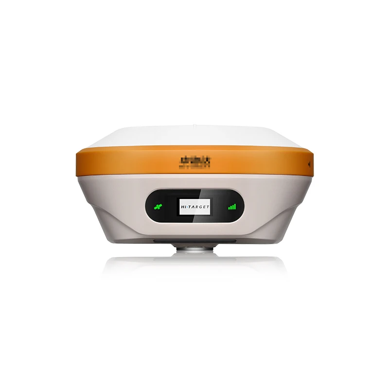
User Interface | Button: Double button | |
Display: 0.94-inch 240*120 high-resolution OLED high-definition color display | ||
LED prompt light: satellite light, signal light | ||
Functional application | Advanced features: NFC IGRS, WebUI interaction, U disk firmware upgrade | |
Intelligent application: intelligent voice, function self-check | ||
Remote service: message push, online upgrade, remote control | ||
Cloud services: device management, location services, collaborative work, data analysis | ||
physical properties | Host battery: built-in high-capacity lithium battery 6800mAh, working time is better than 13 hours | |
Support fast charge: support USB PD3.0, 57W super fast charge | ||
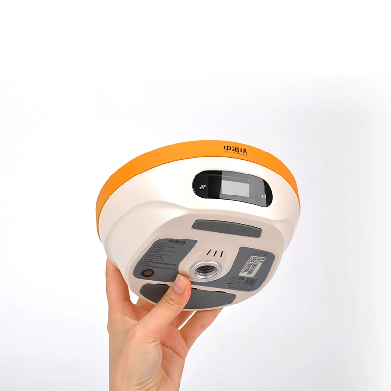
External power supply: 6~28V wide-voltage DC design, 5-core interface | ||
Size: Φ156mmx77mm | ||
Weight: | ||
Power consumption: 2.6W | ||
Material: The outer casing is made of magnesium alloy material | ||
Environmental characteristics | Dust and Waterproof: IP68 | |
Drop resistance: natural drop resistance of 2 meters high measuring rod | ||
Relative humidity: 100% non-condensing | ||
Operating temperature: -45°C~ 75°C | ||
Storage temperature: -55°C~ 85° | ||
"Note: [1] BDS B2b, GALILEO E6, QZSS L6, IRNSS L5 are available via firmware upgrade. [2] The measurement accuracy, accuracy, reliability and initialization time depend on various factors, including tilt angle, number of satellites, geometric distribution, observation time, atmospheric conditions and multipath validation, etc. The data is obtained under normal conditions. [3] Irregular operations such as rapid rotation and high-intensity vibration may affect the inertial navigation accuracy. [4] The battery working time is related to the working environment, working temperature and battery life. " | ||
Handbook technical parameters | ||
System Configuration | OS: Android 10 OS | |
Processor: 2.0GHz, 8-core processor | ||
Storage: 32GB large capacity, support T-Flash memory card, support up to 128GB | ||
Display: 5.5-inch high-brightness outdoor color capacitive touch screen | ||
Display resolution: 720*1280, typical brightness 600 nits | ||
Input: physical full keyboard, number and letter partition, professional customized physical keyboard intelligent input method | ||
GNSS features | Positioning: built-in GNSS antenna, support GPS Beidou GLONASS, support AGPS | |
Communication configuration | Cellular mobile: built-in 4G full Netcom, dual-card dual-standby, built-in eSIM card, including three years of data | |
WiFi: IEEE 802.11b/g/n, Wapi, AP (support WiFi and cellular mobile dual-connection smart Internet access) | ||
Bluetooth: Built-in Bluetooth (2.1 4.0 5.0) | ||
NFC: Support NFC IGRS | ||
USB: USB Type C interface, support OTG function | ||
Power performance | Built-in battery: non-removable lithium battery, 8500mAh, support fast charge | |
Working time: can work continuously for 22 hours | ||
Functional application | Camera: Built-in 13 million pixel camera (with flash) | |
Flash: high-brightness Flash LED flash, (support torch function) | ||
Microphone: Built-in microphone, with voice annotation function | ||
AR lead Y: support AR image real scene measurement | ||
Sensor: gravity sensor, geomagnetic, light sensor, gyroscope | ||
physical properties | Dimensions: 236mmx85mmx24.5mm | |
Weight: 465g (including battery) | ||
Temperature: -20°℃~ 60°℃; Storage temperature: -30°℃~ 70°℃ | ||
Dustproof and waterproof: IP68; resistant to free fall from 1.8 meters | ||
Company Profile


chengdu dongying space surveying and mapping instrument co.ltd inJanuary 2013,is a professional manufacturer andexporter that is concerned with the sale, development and production ofSurveying instrument. We are located inChengDu, with convenient transportation access. All ofour products comply with international quality standards and are greaappreciated in a variety of different ChengDu and are currently exporting20% of our production worldwide.
Ourwquipped facilities and excellent quality control throughout all stages of productionabto guarantee total customattaction. As a result of our high quality products and outstanding customer service, wehave gained a global sales network reaching(Indonesia.Southeast Asia.South Asia.Africa.Russia.Middle East)you are interested in any of our products or would like to discuss a custoorder, please feel free to contact us.e looking forward to forming successfubusineselationships with new clients around the world in the near future.
Sample


Packing & Delivery

Customer Photos


FAQ
1. Whats your payment method?
We accept T/T in advance,L/C at sight, Western Union, Moneygram, Paypal, Secure Pay-ment(Alibaba) and Credit Card.
2. How can you guarantee the safety of my funds?
Trust is always a big problem for international trade, we believe good business credit and reputation is the most important for businessman. We recommend Trade Assurance ser-vice by Alibaba Group. We wont get the fund unless you get the product and confirm the payment.
3. What Countries do you ship to?
We ships goods to almost all countries by express, air or sea. And we willinform you if we cant ship to your country.
4. Are your products in stock?
Most items are usually in stock. It all depends on promotions we run, demand at manufac-turers and suppliers. Most delivery will be made within 3 working days after payment con-firmed.
5. Do you sell used surveying equipment?
We do not sell any used equipment. Everything we sell is brand new. For some equipment we may need to test or check the language before delivery.
6. Do you have other items that are not displayed on your website?
Yes, we have other items that we do not display on our website. Please contact us and let us know what you are looking for as long as its surveying related.
Похожие товары


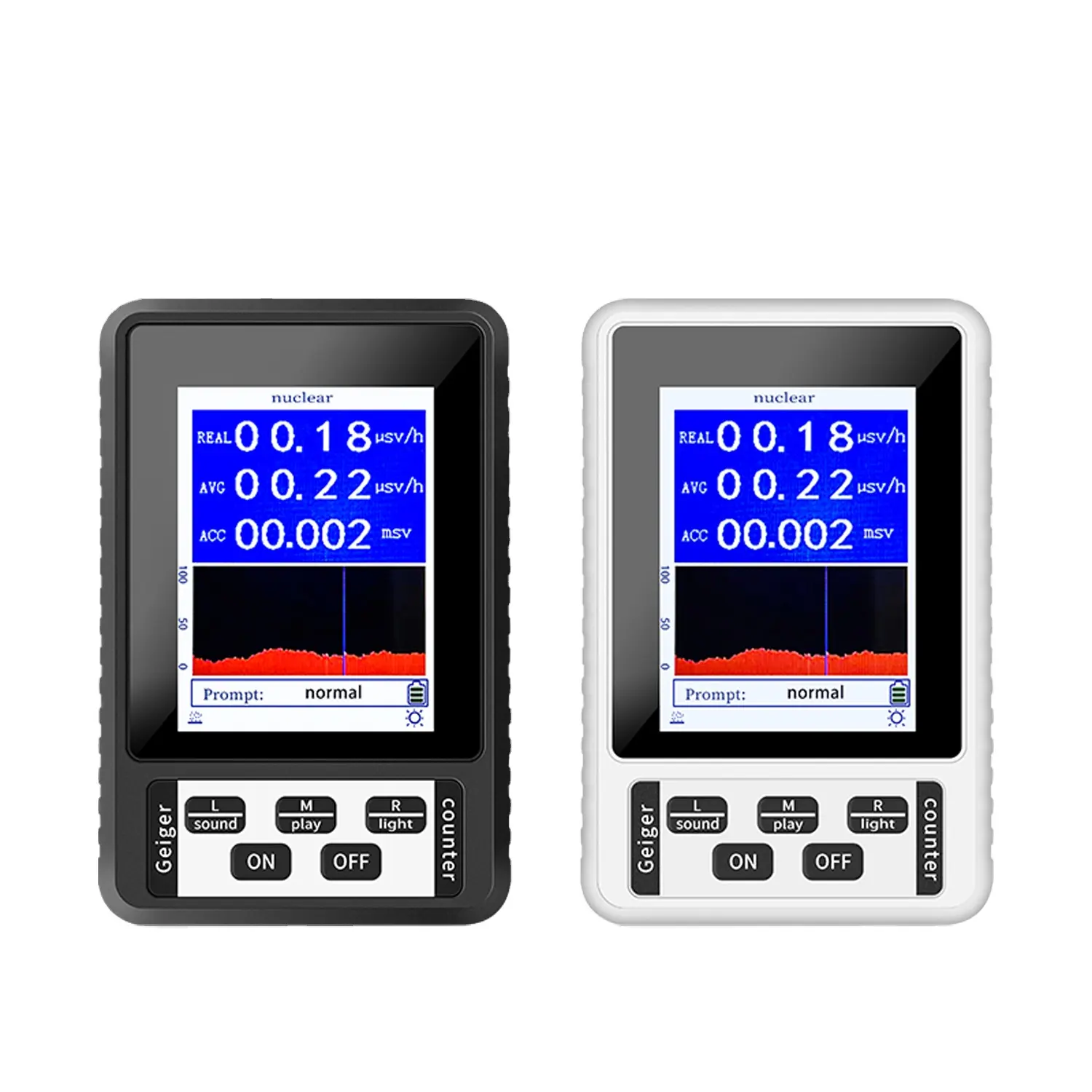
Датчик ядерной радиации Geiger Counter
US $39.50-$45.00


Портативный Тестер 100 кГц LCR USB портативный измеритель VC4080 LCR
US $88.00-$226.00